| (D)GPS |
The US GPS (NAVSTAR) system is the dKart Navigator main source of ship positioning data. The GPS receiver provides data for the calculation of ship position, course and speed. The dKart software is compatible with all GPS receivers using the NMEA-0183 (IEC 61162-1) standard protocol.

The dKart Navigator systems also accept and process the additional positioning data obtained from the IALA DGPS (Differential GPS) beacons, enhancing the accuracy of position presentations.
*close window* |
| |
| (D)GLONASS |
GLONASS (Global Navigation Satellite System) is the Russian counterpart of NAVSTAR GPS. Optional receivers may combine GLONASS and GPS reception, enhancing the accuracy and reliability of positioning calculations.
The dKart Navigator systems are able to process data from either a GPS or a GLONASS receiver, as well as from a combined receiver.
*close window* |
| |
| Speed Log & Compass |
With a speed log and an electronic compass connected, the dKart Navigator will display a corresponding vector arrow, indicating ship speed in water and magnetic heading.
Combined with input from a GPS receiver, AIS transponder, ARPA or LORAN-C, two vectors will be simultaneously displayed on the chart:
- the true motion vector, showing speed over ground and heading based on GPS data, and
- the motion vector showing speed and heading, based on water speed log and magnetic compass data
The dynamic length of the vector arrow may be chosen to represent a time lapse (minutes). The system will adjust the vector length according to ship speed, indicating a predicted ship position at the end of the arrow - after the predetermined number of minutes at unchanged speed.
In case other positioning sensors are missing or faulty, dKart Navigator can provide an approximate track and position display by dead reckoning based on the data received from speed log and compass.
*close window* |
| |
| WIND METER |
The dKart Navigator allows the displaying of speed vector of true or relative wind according to data from a wind meter providing data according to the NMEA-0183 protocol. The following NMEA messages are supported: MDA, MWD, MWV, VMR and VMT. The dKart Navigator uses standard Weather Service symbols to display wind force, and the wind vector is displayed in the same scale as the vector of own ship movement.
*close window* |
| |
| Auto Pilot |
All dKart Navigator versions are prepared for auto pilot connection, by the NMEA-0183 protocol.
Using the Route Planning feature, the dKart Navigator will control the auto pilot to follow a preplanned route line. The system allows for the setting of temporary WayPoints - e.g. for collision avoidance - returning to the planned route by a simple key command.
*close window*
|
| |
| Echo Sounder |
All versions of the dKart Navigator are prepared for Echo Sounder connection, collecting sounder data by means of the IEC 61162-1 (NMEA-0183) protocol. The incoming data are used by the system to warn of dangerously shallow depths. The sounder data are saved by the system and may be graphically displayed as a bottom relief curve.
The dKart Navigator 6.x version is capable of converting sounder data into survey worksheets, to produce your own chart layer. The converted data can be directly displayed on chart. Manual data editing is possible. A word of warning: the collecting of survey data may be prohibited in some restricted areas.
*close window*
|
| |
| ARPA |
The higher-end dKart Navigator versions can optionally collect and process radar data in the NMEA-0183 format from ARPA and MINI-ARPA radars, to be displayed on the navigation monitor. The radar picture presentation is selectable as a chart overlay or in a separate window.
The ARPA targets are displayed on chart. The dKart system will contineously predict and compare all ARPA target and own ship movements, checking for collision risks. Targets identified as potentially dangerous will change colour and trigger visual and acoustic warnings. The dKart Navigator offers extensive target information, such as speed, heading, bearing distance, approach distance and calculated time of possible encounter.
*close window*
|
| |
| AIS Transponder |
The AIS (Automatic Target Identification System) Transponder is classified as compulsory in IMO regulations, and will eventually be required equipment onboard all ships above 300 GRT, with a few exceptions.
For traffic control and safety purposes the AIS Transponder offers several advantages over radar.
Transponder targets are presented on the electronic chart, much in the same way as ARPA radar targets. However, while ARPA targets will be found only within radar reach and get lost in radar shadow - there is no technical limit as to AIS target location or distance.
Basically, the AIS target information is transmitted on VHF frequencies. Directly from ship to ship, or via land based VHF repeater stations. Using future satellite repeaters, AIS targets can be identified anywhere in the world. It will become possible to track real time ship movements on chart from port to port over the oceans.
The AIS was designed to provide mariners with the most precise and detailed data on all detected targets. This includes the target's absolutely precise position, heading and speed data, as measured by the target ship itself.
Additionally, by clicking on the target marker, information will be displayed including ship owner name, ship name, ship type, displacement, draught and dimensions, the route and destination, type of transported cargo and/or number of passengers.
Furthermore, the AIS system provides for intership exchange of written messages by which it is possible to avoid all misunderstandings in the event of necessary course adjustments for collision avoidance.
By adding the SAAB TransponderTech AIS Transponder to your dKart Navigator, you will enter a new world of traffic information. The SAAB Transpondertech AIS Transponder received FCC and USCG certification.
*close window*
|
| |
| NAVTEX |
NAVTEX is an international network for the broadcasting of Navigational, Meteorological and Ice warnings, Search & Rescue (S&R or SAR) information and Weather forecasts. Transmissions take place on 516 kHz in FEC digital format (Forward Error Correction).
The dKart Navigator is capable of collecting data from a NAVTEX receiver, to display navigational warnings on the computer screen.
*close window* |
| |
| Additional Position Sensors |
The dKart Navigator will accept data input from additional positioning sensors, e.g. a second GPS receiver or a LORAN-C receiver providing data in the NMEA-0183 protocol format. You may simultaneously employ several positioning sensors - each displaying its ship position marker on screen and thus providing a simple approach to the checking of accuracy and reliability of devices, by comparison.
*close window* |
| |
| CM93/3 Chart Format |
The dKart Navigators are optimized for use with the CM93/3 vector electronic charts developed by the C-Map company. C-Map's world wide chart collection is a "de facto" marine standard for professional electronic chart applications.
The structure of the CM93/3 vector electronic chart data is a graphic equivalent of S-57/3 (3.1) data. The CM93/3 charts are distributed on CD-ROM and are updated at regular intervals.
*close window*
|
| |
| CM93/3 Database Check |
At start, the dKart Navigator will perform a diagnostic check of the CM93/3 chart database including applied updatings. The testing progress will be shown on screen.
*close window*
|
| |
| S-57 Exchange Data |
The S-57 standard was developed by the International Hydrographic Organization (IHO) for the purpose of official cartographic data exchange between hydrographic organizations, S-57/3.1 being the latest version. S-57 data must be converted to a graphic format (such as C-Map CM93) to become presentable as a chart on the navigation monitor screen.
In accordance with the requirements for electronic cartographic navigational systems to be certified as ECDIS, the dKart Navigators accept chart data based on editions S-57/3 and S-57/3.1 as well as the old S-57/2 (DX90) version.
*close window*
|
| |
| Hydrographic Survey Worksheets |
The dKart Navigator 6.x version is capable of converting sounder data into Survey Worksheets, to produce your own chart layer. The converted data can be directly displayed on chart. Manual data editing is possible. A word of warning: the collecting of survey data may be prohibited in some restricted areas.
*close window*
|
| |
| CM93/3 Chart Automatic Updating |
Text pending.
*close window*
|
| |
| Chart Manual Updating |
Using the "Manual Updating" facility, the Operator can make own chart corrections. The tasks are quite simple and may be conducted at sea. Corrections made via the manual updating are recognized by the dKart Navigator when looking for obstacles to navigation safety.
*close window* |
| |
| User Objects editor |
With the help of dKart Navigator User Layer editor you may add own objects and comments as chart overlays. The following object types may be added:
- areas
- lines
- symbols
- texts
You may select colour, footprint as well as orientation and size (for symbols and texts), fill colours and patterns (for areas and lines). Symbols may be selected from a pop-up list of S52 symbols.
User objects are grouped into a number of User Layer's according to the Operator's choice. Original cartographic data remains unchanged.
In contrast to Manual Updating, User Object data are valid only for on-chart display. The system does not recognize User Objects when looking for obstacles in navigation safety tasks.
*close window*
|
| |
| Horizontal Datum |
You may select a horizontal datum for chart presentation from a list of more than 280 ellipsoids, according to S-60 regulations. WGS-84 (World Geodetic System 1984) is the default.
*close window* |
| |
| Automatic Chart
Selection and Loading |
During the voyage, the dKart Navigator automatically selects and displays on screen the most detailed chart available at the ship position.
By the user-friendly interface, you may manually switch to any other available chart or scale.
Before the ship leaves a chart zone the next chart is automatically loaded.
*close window* |
| |
| Chart Multiloading |
The dKart Navigator can simultaneously display charts in different formats, such as CM93/3, DCF (dKart Chart S-57 Format). Alternatively, charts of different scales may be loaded for the best possible chart presentation.
*close window* |
| |
| Chart Presentation Levels |
The dKart Navigator offers several levels of chart presentations, selectable by preference:
- Basic level to display the objects of high importance to safe navigation, e.g. Safety Contour, Obstructions, Land Areas etc. These objects cannot be removed from the display.
- Standard level to display the basic level data and, additionally, such objects as Navigational Aids, Restricted Areas etc. The dKart Navigator will show the standard presentation level at start, by default.
- Full level to display all available chart objects.
- Custom level to display object groups according to own requirements (valid for chart format CM93/only).
*close window*
|
| |
| Chart Palettes |
The selectable screen colour palettes support the optimization of chart readability under different ambient light conditions, and serve to protect the navigator's night sight.
*close window* |
| |
| True Motion |
In True Motion mode, the own ship symbol moves across a fixed chart display. As the ship moves towards a chart edge, the look-ahead area is crimping. To compensate, the dKart Navigator supports the setting of a "trigger distance" for chart paging. At this distance from the chart edge, a new chart page is automatically displayed - with the ship symbol again in the center, or in the offset position previously determined by the operator. By proper choice of the offset position and chart paging trigger distance, the operator can ensure maximum look-ahead area in the chart window.
*close window* |
| |
| Relative Motion |
A mode of chart display, where the ship movements are represented by a scrolling chart image under the own ship symbol. The ship symbol remains stationary at the center of the chart window, or may be relocated by the operator to show maximum look-ahead area.
*close window* |
| |
| Chart Orientation (Head Up/North Up) |
The chart orientation and scale may be changed at any time, to support the momentary navigational situation. For instance, you can select the "Head Up" orientation mode by which the dKart Navigator will automatically rotate the chart, keeping stationary the direction of the ship movement vector. This mode may simplify the identification of islands and other objects - the objects and the seascape will appear on chart as observed from the wheelhouse.
The "North Up" mode will show the ship moving on a North Up oriented chart. In both modes, you may change the chart scale to see the charts of adjoining areas.
*close window* |
| |
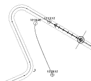
| Route Monitoring |
In its Route Monitoring mode, the dKart Navigator exhibits the information on ship position and movement elements, including heading/true heading, speed/true speed, speed and heading incremental/decremental values, current time, etc. The navigation data are updated every second and are displayed both as numerals and directly on the chart. The pathway with time stamps is displayed on the chart.
*close window* |
| |
| Route Calculations |
While a ship is moving along a route, the dKart Navigator system will continously provide information about route name, distance, bearing and estimated time to the nearest WayPoint.
The system further supports Operator adjustments of course and speed - as needed to arrive at the WayPoint within seconds of the required time. This feature is particularly useful when the opening time of a bridge or water-lock has been agreed upon. Mooring or holding the vessel against wind and/or currents at such destinations can easily be avoided.
The dKart Navigator will warn you of dangerous deviations from the route XTE corridor - and thus offers an opportunity to prepare for course adjustments in time.
*close window* |
| |
| Event Mark |
This function allows you to keep track of the ship position in relation to a chart point, selected by setting an "Event Marker". To trigger an Event Marker alarm, one of the following (preselected) conditions must be met:
- the ship arrives at the position where the ship-to-marker bearing becomes identical to a preset value, determined by the operator
- the ship arrives at the position were the ship-to-marker bearing is exactly abeam
- the ship arrives at the position where the ship-to-marker distance becomes identical to a preset value, determined by the operator
- the ship has drifted to arrive at a ship-to-marker distance equal to a preset value, determined by the operator
When the selected event occurs, dKart Navigator will issue an acoustic and visual warning.
*close window*
|
| |
| Plotting/Reckoning Modes |
Any of the following positioning devices may be selected for the primary (main) plotting mode:
- GPS, AIS-Transponder, ARPA, DECCA, LORAN-C automatic systems - in combination with electronic log and (gyro) compass
Secondary (emergency) reckoning mode:
- Reckoning on the basis of heading and speed data, including a log and compass as a minimum. Alternatively, data may be entered manually by the operator
- In case of failure of the positioning device(s) selected for the main plotting mode, the dKart Navigator will automatically change to the secondary (emergency) reckoning mode
The abovementioned types of positioning devices may be used for both primary and emergency modes.
*close window*
|
| |
| Dual Plotting |
In the Dual Plotting mode the dKart Navigator will use two positioning sensors, simultaneously. It allows an operator to estimate the accuracy of devices, as well as detect possible malfunctioning.
*close window* |
| |
| ARPA/AIS Plot |
The ARPA Plot function helps you make a position fix based on ARPA reference targets, such as well defined capes. The dKart Navigator allows using from 1 to 10 targets for the purpose. As long as this function is active, the ship position is contineously displayed on chart - as a symbol labelled "EP ARPA".
*close window* |
| |
| Manual Position Fix |
This function allows you to determine the ship position, by manual entering of bearings and distances to visible landmarks.
*close window* |
| |
| Safety Zone |
You may determine a safety zone for the ship, as a circle sector ahead - with selectable angle and radius.
When a dangerous object is identified within the safety zone, the dKart Navigator will issue acoustic and visual alarm indications.
*close window* |
| |
| Safety Depth, Contour and Area |
You may use this function to show on chart the contours of areas having depths less or equal to ship draught. Similarly, the contours of areas of restricted navigation can be visualized.
When crossing the contour of such dangerous or restricted areas, the dKart Navigator will issue acoustic and visual alarm indications.
*close window* |
| |
| Route Planning |
By the Route Planning function, you can draw a new route directly on the chart. You can specify WayPoints with arrival circle or distance, route deviation limits (XTE), gyration radius and other parameters both in numerical form and on the chart.
With an Auto Pilot connected, the dKart Navigator can steer the ship along a planned route.
*close window*
|
| |
| Route Safety Check |
This function will check if navigational obstacles, hazardous depth areas or areas with navigational restrictions will be encountered along a planned route.
*close window* |
| |
| Route Export and Import |
This function provides for export and import of Route Data, allowing the exchange of such data between ships - and between ships and shore.
*close window*
|
| |
| GPS WayPoints Export and Import |
The dkart Navigator supports Route Data Exchange between the electronic chart system and external navigation devices. For example, the import of WayPoints from a GPS receiver to the dKart Navigator. The data exchange is carried out by means of .WPL and .RTE data files, according to the IEC 61162-1 (NMEA-0183) protocol.
*close window*
|
| |
| Rhumb Line |
The "Rhumb Line tracking" is the default mode of Route
Planning, available in all versions of the dKart Navigator. In this mode, a route will consist of rectilinear segments in the Mercator projection. This mode is standard for short distance navigation.
*close window* |
| |
| Great Circle |
The 'Great Circle planning' takes into account the Earth's globular form, and is used for long distance navigation. It provides for the shortest possible track between two points on the earth sphere.
*close window* |
| |
| Route Creation from Log/Track |
dKart Navigator higher-end versions provide for a recorded target or ship track to be automatically converted into a route, e.g. for running the same track by auto pilot assistance.
*close window* |
| |
| Electronic Log Book |
The principal navigational information is automatically logged and may be replayed at will. The logged information includes the chart in use, the on-chart position and track of own ship and ARPA/AIS targets, along with information about changes in operating modes or conditions in the navigational system and onboard devices, and the Navigator's own notations.
The electronic log book data may be exported and imported, to relay the log information to other ships or to a shore-based archive. You can organize the log information in a table and/or send momentary chart images to a printer.
An electronic navigational logbook may be considered as a "black box" permitting playback of a recorded situation. In the case of maritime inquiries triggered by accidents at sea, the log contents may or may not be taken into account - depending on individual court decisions.
*close window*
|
| |
| Logbook Replay on Chart |
Using the dKart Navigator electronic logbook function, you may instantly play back the navigation history on the system monitor. You may select any time period, the direction of playback (forward or backward) and set the playback speed.
*close window* |
| |
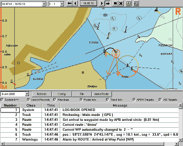
| Arrival at WayPoint |
An acoustic indication will be given when the ship reaches the predetermined arrival circle or arrives at predetermined distance from the waypoint.
*close window* |
| |
| External Device Malfunction |
Having detected the malfunctioning of any connected navigation device, the dKart Navigator will immediately warn by visual indication.
*close window* |
| |
| Deviation from Route XTE Corridor |
Having registered a deviation from the assigned route by a value larger than has been preset by the navigator (the XTE Corridor), the dKart Navigator will immediately issue an acoustic and visible warning.
*close window* |
| |
| Shallow Water Alarm |
When a connected sounder registers a depth less than the preset Safety Depth (draught plus safety margin), the dKart Navigator system will immediately issue an acoustic and visible warning.
*close window* |
| |
| Safety Contour Crossed |
When crossing the contour of an area of dangerous depths, or a restricted area, the dKart Navigator will issue acoustic and visual alarm.
*close window* |
| |
| Dangerous Object in Safety Zone |
The Safety Zone is a circle sector ahead - with angle and radius selectable by the Operator.
When a dangerous object emerges within the Safety Zone - such as reefs, sunken vessels or any other such object found in the chart database, the dKart Navigator will sound an alarm accompanied by visual indication.
*close window* |
| |
| Special Conditions Area Approach Alarm |
The dKart Navigator will warn when the ship is entering an area prohibited for navigation or an area with special conditions of navigation.
*close window* |
| |
| Dangerous Depth Alarm |
This function will warn when the ship is entering an area of hazardous depths. The dKart Navigator will sound an alarm signal accompanied by visual indication.
*close window* |
| |
| Dangerous Target Indication |
The dKart Navigator uses a colour indication in order to attract navigator's attention to potentially dangerous ARPA and AIS targets. The dangerous targets are coloured in red on chart.
*close window* |
| |
| System Integrity Check |
System files are automatically checked at program startup, and once every hour during program operation. Optionally, the file integrity check may be manually activated at any time. A screen message will be shown in case of errors found.
*close window* |
| |
| Search & Rescue Planning |
This module provides all the necessary means for planning, monitoring and supporting Search and Rescue operations - in full accordance with IMO MERSAR and IMOSAR recommendations. It is possible to plan one-ship, multiple-ship, ship/aircraft S&R operations in different modes based on the ship's drift vector, visibility distance, and Man over Board sensor data.
*close window* |
| |
| 3D Sea Bottom View |
This function allows the creation and viewing of a 3D model of the sea bottom. As a source of information, the chart data and echo sounder information are used. The possible applications of this function are: maneuvering in narrow waters and unfamiliar navigation areas, hydrographic activities, fishing etc.
*close window* |
| |
| Navigational Calculator |
A time-saving function, providing fast and accurate results. Two main tasks are supported, the calculation of distance and bearing between two geographical points, and the coordinates of a remote point defined by distance and bearing from any other point. Either Great Circle line or Loxodromic calculations may be employed.
*close window* |
| |
| Survey Data Display and 3D |
The integrated survey database stores depth data collected from an Echo Sounder, the data may also be manually entered. Data from Sounder are shown on-chart in red, manual data in green colour. Please note that depth data will not be shown when the chart scale is less than 1:500 000.
A 3D sea bottom model is created by the program, based on the bathymetrical information in the chart database, or on depth information from the Echo Sounder, or from both sources in combination.
*close window* |
| |
| Ship Model and Trial Maneuvering |
|
Allows the calculation and on-chart display of the trajectory when changing the ship course, based on its dynamic model. The dKart Navigator supports a library of about 20 dynamic models.
*close window* |
| |
| Tides Database |
The Tides Database contains a number of tide gauges. The module enables calculation of the tide level at a specified point (gauge) and time.
*close window* |
| |
| Tidal Current Calculation/Prediction |
The dKart Navigator calculates and displays on-chart the tidal current vectors at points where the Tides Database provides information. The vectors are displayed as red arrows with speed indication in knots.
*close window* |
| |
| River Level Prediction |
The dkart Navigator uses information from the water level gauges to predict the present river water level.
*close window* |
| |
| Dual Screen Presentation |
This feature noticeably expands the capabilities of dKart Navigator software in cartographic data presentation. By means of the Dual Screen function, you may display and work with two different geographic locations - simultaneously displayed on different monitors.
This feature may be used for navigation control on one screen while performing Route Planning on the second.
*close window* |
| |
| LAN Extension |
The dKart Navigator may be configured to operate in a Local Area Network (LAN), allowing interaction between several network computers with dKart Navigator installed. The network will include a MASTER computer, receiving and processing the data from navigation devices - and one or several SLAVE computers, receiving data from the MASTER.
The network makes possible the installation of slave computers on the Bridge Wings, at the Chart Table, in the Captain's cabin, in the Engine Room - in any location where the monitoring of ship movements on chart may be an aid to safety at sea.
*close window* |
| |
| Navigation Data Redirection |
The dKart Navigator supports the redirection of navigation data (NMEA messages) via LAN and/or COM-port. You may select any NMEA message identifier, allowing the dKart Navigator to appear as any transmitting navigation device - to serve as a signal generator for the purpose of fault finding in on-board navigation systems using the NMEA protocol for data transfer between devices.
*close window* |
| |
| Standard Macros |
Add-on macros support the screen presentation of information from third-party available data sources, such as:
- Ice charts database (vector and raster)
- Weather charts database
- Surface currents database
*close window* |
| |
| Custom Macros |
We offer the development of macros for the processing and on-chart presentation of data from an existing database of any structure.
We also develop software for collecting, organizing and storing database information according to customer requirements. As an example, the information may consist of object symbols, text overlays, and/or photos - with positioning data.
*close window* |
| |
| Radar Module |
The optional Radar Module is a software/hardware combination allowing presentation of the radar image as an overlay to the electronic chart, or side-by-side.
A PCI plug-in radar processing board connects the chart system to the radar video and sync circuits. The received radar image is user controlled from the dKart Navigator, independent of radar hardware.
By comparing the radar and chart images, the Operator can enhance his apprehension of the navigational situation. The seascape and ship position is contineously visible on chart, while the radar picture adds information on non-cartographic obstacles - like other ships.
ARPA targets are presented on-chart, as are AIS Transponder targets. The transponder adds comprehensive and accurate information on ship targets, such as ship name, type, size, course, speed and destination. Alone, the radar image offers limited information - land contours and obstacles in radar shadow will remain unseen. The electronic chart and the AIS Transponder will fill in the details.
*close window* |
|
)
)
)
)